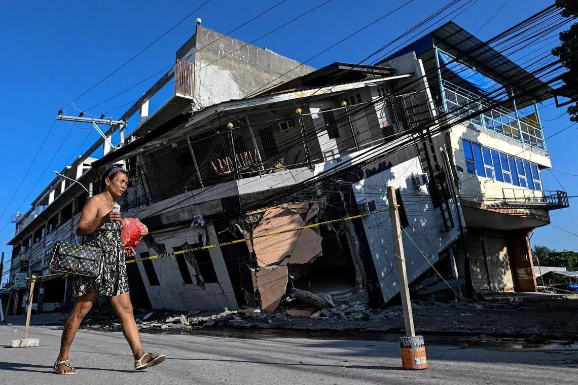
The moment Arsenio Butil Jr felt the ground begin its violent convulsion on June 8, the fisherman and pastor in Glan, Sarangani province, did what instinct demanded—he dropped to his knees and prayed. What unfolded before his eyes in those terrifying seconds would become the defining memory of the disaster: a shoreline that was literally rewriting itself in real time. The once-familiar coastline of the southern Philippines transformed as massive sections of the seafloor buckled upward, thrusting previously submerged coral formations above the waterline in a raw, chaotic display of geological upheaval. The 7.8-magnitude earthquake, one of the strongest to strike the region in years, killed at least 76 people across Mindanao, toppled buildings, and triggered devastating landslides. But beyond the immediate human toll lay something equally sobering—a permanent alteration of the physical landscape that would reshape the lives of fishing communities for generations to come.
The tectonic mechanism driving this dramatic transformation was the shifting of the Cotabato Trench, a major fault line situated as close as 50 kilometres off the coast of Mindanao. This underwater chasm sits at the intersection of complex plate boundaries and has long been recognized as a source of significant seismic hazard in the region. The trench's movements don't happen in isolation; they represent part of a much larger pattern of crustal deformation that has been occurring across this part of the Philippines for millennia. A United Nations disaster risk reduction report released in mid-May had warned that a swarm of thousands of small tremors recorded in January around the Cotabato region could potentially signal a precursor to a major earthquake event. Those warnings proved prescient when the June 8 quake struck with devastating force.
The phenomenon that observers witnessed along the affected coastline—called coastal uplift in seismological terms—resulted in one of the most visually striking and permanent changes to the landscape. According to Nane Danlag, a scientist at the Philippines' seismology centre, the seabed rose approximately two metres during the earthquake. This vertical displacement, though seemingly modest in absolute terms, extended the coastline by as much as 200 metres in some locations across an affected zone stretching nearly 100 kilometres between two towns. The new shoreline is utterly permanent; there is no geological mechanism that would reverse this change. Where families had fished for generations in waters now transformed into dry land, boats that once floated at the water's edge now sat stranded on the wrong side of jagged, lifeless coral walls.
Butil Jr recounted the surreal experience of witnessing these changes unfold during and immediately after the quake. He described the water receding dramatically, then returning, then receding again—a pattern that repeated multiple times. As the seawater pulled back from the shore, fish that had been caught in shallow pools began to die, their bodies floating in the remaining water. For a man who had lived his entire life reading the sea and depending upon it for his livelihood, the experience was profoundly disorienting. He emphasized that the June 8 earthquake was the most violent seismic event he had ever experienced, and the panic that gripped the community was immediate and visceral. The terror was not merely about the shaking itself, but about the unknown: what might come next.
The displacement of people from affected coastal areas has created ongoing humanitarian challenges. In the hills above a neighbouring village, approximately 100 residents—fishermen, their families, women, and children—had established an encampment on higher ground where they sought refuge after the earthquake. Weeks after the initial disaster, these families remained reluctant to descend to their destroyed homes despite the passage of time. Datu Atom Malimpnig, a Maguindanaon chieftain representing the community, explained that residents harbored deep fears about the possibility of a tsunami striking the newly altered coast. The psychological impact of witnessing such dramatic geological change, combined with the knowledge that the seabed had risen and the shoreline was fundamentally different, created a pervasive sense of vulnerability. Many residents felt that their elevated position in the hills offered greater security than rebuilding in the same location, even as government aid workers distributed rice porridge to the evacuees below.
The economic consequences of the coastal transformation extend beyond the displaced communities to the broader tourism sector that depends on the region's natural attractions. At the Isla Jardin del Mar resort, staff member Edzel Baylon confronted a stark commercial reality: the resort's primary marketing asset—a pristine white sand beach suitable for swimming and recreation—had been rendered unusable. The newly exposed coral that now separated the beach from deeper water had rendered the swimming areas shallow and inaccessible. For a destination whose entire business model relied on promoting a tropical seaside experience, the earthquake had fundamentally undermined the natural environment that generated revenue. The transformation of the seascape from asset to liability illustrated how geological events can devastate not just individuals and families, but entire economic sectors that depend on stable environmental conditions.
The seismic activity in the region shows no signs of stabilizing. Since the June 8 earthquake, the seismology agency recorded more than 8,500 aftershocks, a staggering number that reflects the degree of crustal stress that remains unresolved in the Cotabato region. These continuing tremors, ranging from minor to significant, perpetuate the anxiety among residents and complicate any efforts at rebuilding and recovery. Butil Jr observed that the ground in Glan remained visibly cracked—long, deep fissures that serve as physical reminders of the forces that had been unleashed. These cracks represent genuine structural hazards; another earthquake of comparable magnitude could cause catastrophic additional damage to any structures rebuilt in the same location. The prospect of future seismic events of equal or greater intensity cannot be dismissed, given the historical frequency of major earthquakes in the Cotabato Trench region.
For residents and officials grappling with recovery, the path forward remains uncertain and fraught with difficult decisions. Butil Jr indicated that people in Glan were contemplating next steps but had not yet begun attempting to reconstruct their destroyed homes. The calculus of rebuilding in an active seismic zone is complex: do communities invest in reconstructing in vulnerable coastal areas, or do they attempt to relocate to higher ground? Government support for either option remains limited, leaving many residents in a state of limbo. The newly formed coastline, while geologically fascinating to seismologists, represents a barrier to economic recovery for the fishing communities whose livelihoods depended on access to the sea. The permanent nature of the coastal change means that adaptation, rather than restoration, has become the only viable long-term strategy.
%22%2F%3E%3C%2Fpattern%3E%3C%2Fdefs%3E%3Crect%20width%3D%22100%25%22%20height%3D%22100%25%22%20fill%3D%22url(%23ph1o7vjg)%22%2F%3E%3Crect%20width%3D%22100%25%22%20height%3D%22100%25%22%20fill%3D%22url(%23ph1o7vjp)%22%2F%3E%3Ctext%20x%3D%2250%25%22%20y%3D%2250%25%22%20text-anchor%3D%22middle%22%20dominant-baseline%3D%22central%22%20fill%3D%22rgba(255%2C255%2C255%2C0.95)%22%20font-family%3D%22Georgia%2C%20'Times%20New%20Roman'%2C%20serif%22%20font-weight%3D%22700%22%20font-size%3D%22320%22%20letter-spacing%3D%22-0.02em%22%3EPM%3C%2Ftext%3E%3C%2Fsvg%3E)
%22%2F%3E%3C%2Fpattern%3E%3C%2Fdefs%3E%3Crect%20width%3D%22100%25%22%20height%3D%22100%25%22%20fill%3D%22url(%23ph2hltqg)%22%2F%3E%3Crect%20width%3D%22100%25%22%20height%3D%22100%25%22%20fill%3D%22url(%23ph2hltqp)%22%2F%3E%3Ctext%20x%3D%2250%25%22%20y%3D%2250%25%22%20text-anchor%3D%22middle%22%20dominant-baseline%3D%22central%22%20fill%3D%22rgba(255%2C255%2C255%2C0.95)%22%20font-family%3D%22Georgia%2C%20'Times%20New%20Roman'%2C%20serif%22%20font-weight%3D%22700%22%20font-size%3D%22320%22%20letter-spacing%3D%22-0.02em%22%3EPAS%3C%2Ftext%3E%3C%2Fsvg%3E)