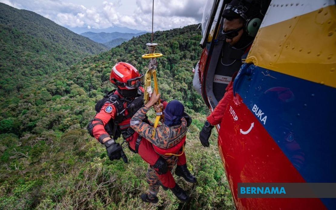
The alarming frequency of hiking-related incidents across Malaysia has prompted the government to take decisive action on trail safety and emergency preparedness. Between 2021 and 2025, the nation experienced 1,059 accidents linked to hiking activities, claiming 63 lives and leaving 87 others injured, according to data from the Fire and Rescue Department of Malaysia presented in Parliament by Deputy Minister Syed Ibrahim Syed Noh. The escalating toll underscores the tension between Malaysia's growing outdoor recreation industry and the infrastructural gaps that have historically plagued rescue operations in remote forest zones.
The surge in incidents reflects the nation's expanding middle class and rising leisure time for adventure activities, particularly among urban professionals seeking weekend getaways. Permanent Reserved Forests across Peninsular Malaysia have become increasingly accessible, yet many trails remain inadequately mapped and monitored. The statistics revealed to Parliament serve as a sobering reminder that popularity and preparedness have not kept pace equally. Deputy Minister Syed Ibrahim's parliamentary response signals official acknowledgment that voluntary compliance and informal management systems have proven insufficient for protecting the rising volume of recreational hikers venturing into Malaysia's forest reserves.
To address this crisis, the Peninsular Malaysia Forestry Department, supported by funding from the United Nations Development Programme, developed the Mountain Risk Assessment and Management Guideline, known as MoGRAM. This technical framework establishes evidence-based protocols for evaluating hazards, determining safe carrying capacities for individual trails, and implementing mitigation strategies. The guideline represents a shift from reactive crisis management toward proactive risk assessment, though its effectiveness depends on consistent application across the numerous state forestry departments managing forest access permits and trail maintenance.
A cornerstone of the government's revised safety architecture involves the mandatory deployment of certified Forestry Mountain Guides in 189 high-risk hiking areas across the country. These guides, designated as MGPs in official terminology, undergo rigorous training in emergency response, first aid, survival techniques, and hiking best practices. To date, 2,322 individuals from local and indigenous communities have completed the MGP certification programme, creating a network of trained professionals positioned at critical entry points. By drawing from local communities for these roles, the initiative simultaneously addresses unemployment while leveraging indigenous knowledge of terrain and environmental conditions.
The Mountain Guide Programme addresses a critical vulnerability in Malaysia's search and rescue capacity. Professional guides serve as the first line of defense against accidents, capable of identifying hazardous conditions before incidents occur and responding immediately when emergencies strike. Their presence also ensures compliance with established safety protocols and proper documentation of hiker movements. However, scaling this workforce across all frequented trails remains an ongoing challenge, requiring sustained funding and continuous training to maintain certification standards and keep guides informed of evolving safety techniques.
Paralleling ground-level safety improvements, the ministry is developing an integrated digital platform for hiking trail management and hiker registration. In collaboration with the Malaysian Space Agency, authorities are deploying geospatial technology, geographic information systems, and remote sensing capabilities to map and monitor trails with unprecedented precision. This technological infrastructure will enable centralised management of trail information, real-time hazard updates, and enhanced coordination of search and rescue operations when incidents occur. Currently, registration of hiking activities in state forest reserves operates through fragmented manual and online systems controlled by individual state forestry departments, creating gaps in comprehensive data collection.
The proposed national digital hiking registration log system addresses a fundamental bottleneck in emergency response. When hikers go missing or require rescue, delays in determining their location, route, expected return time, and companion details can prove fatal in mountainous terrain. A unified national system would consolidate this critical information, accelerate tracing processes, and provide search teams with accurate, real-time spatial analysis to guide rescue efforts. The system also creates systematic records of hiker movements across the nation, enabling authorities to identify problem areas, enforce trail closures when conditions deteriorate, and gather data to refine future safety protocols.
Implementing such technological infrastructure across Malaysia's diverse geography presents substantial logistical and financial hurdles. Many remote trailheads lack reliable mobile coverage, requiring offline-capable systems and alternative registration mechanisms. Training hundreds of trail wardens and guides to use sophisticated geospatial tools demands sustained investment in technical education. Integration across state-controlled forestry departments necessitates harmonizing different administrative systems and protocols, a challenge complicated by federalism's preservation of state autonomy over natural resources. Nevertheless, the government's recognition of these limitations indicates a willingness to pursue ambitious technological solutions rather than accept the status quo of fragmented, inefficient management.
Beyond immediate safety infrastructure, the ministry emphasises continuous professional development for guides and naturalists who operate on the frontlines of hiker protection. Regular training programmes cover evolving aspects of hiking safety, advanced risk management techniques, wilderness first aid, survival skills relevant to Malaysian terrain, and specialised search and rescue methodologies. This commitment reflects understanding that certification alone provides insufficient protection; guides require updated knowledge as environmental conditions change, weather patterns shift, and emerging hazards emerge. The welfare of these guides is also receiving heightened attention, recognising their demanding working conditions and critical role in the broader safety ecosystem.
For Malaysian hikers and adventure enthusiasts, these policy developments signal a transitional period in outdoor recreation governance. The combination of mandatory guides in high-risk areas, digitalised trail registration, and geospatial monitoring systems will substantially alter the hiking experience, particularly for popular peaks and frequently-accessed reserves. While increased oversight may feel restrictive to experienced hikers accustomed to greater autonomy, the measures directly address the gap between demand and safety capacity that has claimed dozens of lives. The integration of local communities into formal guide roles also opens economic opportunities in rural areas while preserving cultural knowledge about forest environments.
Regionally, Malaysia's approach to hiking safety modernisation offers lessons for neighbouring countries facing similar growth in outdoor recreation with limited rescue infrastructure. Thailand, Indonesia, and the Philippines contend with comparable challenges involving inadequate trail management, insufficient guide standards, and fragmented emergency response systems. Malaysia's investment in geospatial technology and formalised guide certification programmes could serve as a template for regional cooperation on safety standards. However, success ultimately depends on sustained political will to fund these systems over multiple budget cycles and genuine commitment to enforcement of safety protocols rather than permitting shortcuts that undermine their effectiveness.