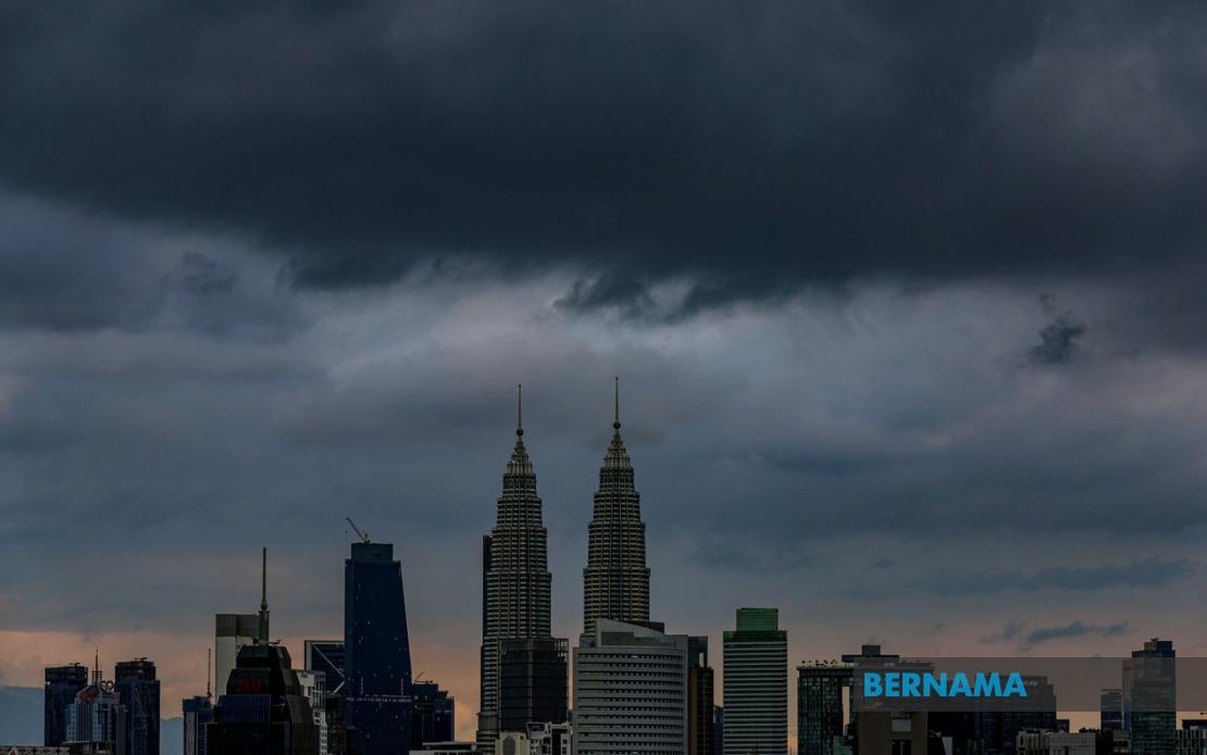
Malaysia's weather forecasters have issued a significant alert for severe thunderstorms and torrential rainfall that will affect the Klang Valley, Putrajaya and a broad swathe of the country stretching from the northern peninsula to East Malaysia, with conditions anticipated to remain hazardous until 7 pm. The Malaysian Meteorological Department issued the warning on June 28, identifying multiple districts and divisions vulnerable to dangerous atmospheric conditions characterised by thunder, substantial precipitation and gusts of wind capable of causing disruption across the affected regions.
The northern peninsula faces particular exposure to the adverse weather system, with residents and commuters across Perlis, Penang and Kedah preparing for potential impacts. Within Kedah, the warning encompasses specific districts including Langkawi, Kubang Pasu, Padang Terap, Kuala Muda and Kulim, suggesting that the weather disturbance has a localised intensity rather than affecting entire states uniformly. Perak residents in multiple locations including the Hulu Perak upland regions, Kuala Kangsar, the industrial hub of Manjung, the tin-mining area of Kinta, Perak Tengah, Kampar and the coastal district of Bagan Datuk should exercise caution during the forecast period.
The atmospheric instability extends eastward across the peninsula's east coast region, where communities in Kelantan and Terengganu face comparable risks. Gua Musang in Kelantan's interior represents one vulnerable area, whilst Terengganu's exposed districts include both coastal settlements like Besut, Kuala Nerus and Dungun alongside inland territories such as Setiu and Hulu Terengganu. This geographic spread indicates that the meteorological system possesses sufficient strength to impact both lowland population centres and higher-elevation regions simultaneously, a pattern consistent with tropical convergence zones that frequently develop during the monsoon transition periods.
The central peninsula region spanning Selangor and Pahang also falls within the warning zone, directly affecting commuters and residents of the Klang Valley conurbation. Selangor's vulnerable areas stretch from western districts bordering the Strait of Malacca including Hulu Selangor, through the capital's satellite municipalities of Gombak, Petaling and Sepang, to the eastern plateau regions of Kuala Langat, Hulu Langat. Pahang's exposure encompasses both the elevated plateau of Cameron Highlands and the lower-lying regions of Raub, Bentong and Rompin, exposing a demographically significant portion of peninsula Malaysia to simultaneous severe weather.
Sarawak, Malaysia's largest state, experiences its own weather challenges under the alert, with the warning covering multiple administrative divisions. Kuching Division faces impacts in both the capital Kuching and the district of Bau, whilst agricultural and inland areas under Serian and Samarahan administrations are included. The warning extends to Sri Aman, Betong and the division centred on Sarikei, with interior regions managed by Sibu Division including Selangau and the coastal municipality of Mukah also affected. Kapit Division's Song and Kapit townships, alongside Bintulu Division's Tatau area and Miri Division's Subis and Miri complete Sarawak's exposure, indicating that the weather system's influence reaches across the state's diverse geography from coastal areas to remote inland territories.
Sabah, the second-largest Malaysian state, similarly confronts multiple sites vulnerable to the forecast adverse conditions. The Interior Division districts of Keningau and Tambunan, located within Sabah's highland regions, represent areas where heavy rainfall poses particular hazards given topographical drainage challenges. Ranau in the West Coast Division, administratively distinct from the capital Kota Kinabalu, sits within the warning zone, as do four districts spanning the Sandakan administrative division: Telupid, Kinabatangan, Beluran and Sandakan itself, suggesting comprehensive coverage of East Malaysia's exposure to the atmospheric disturbance.
The geographic extent of MetMalaysia's warning demonstrates the scale of the meteorological system affecting the nation. Spanning from Perlis at the peninsula's northern extremity through to Miri and Sarawak's border regions represents coverage encompassing well over half of Malaysia's land area and population. The simultaneous issuance across multiple states and divisions suggests a broad weather pattern rather than isolated localised phenomena, consistent with monsoon-related convergence zones or tropical low-pressure systems that periodically develop during transitional seasons when competing air mass interactions generate organised convective activity.
Residents and authorities across the warned areas should anticipate potential disruptions to daily activities during the afternoon and early evening hours. Thunderstorm activity brings not only rainfall but also associated risks including lightning hazards, flash flooding in low-lying terrain, and strong gusty winds capable of damaging loosely secured structures or overturning vehicles on exposed routes. Commuters on major trunk routes traversing affected districts may experience reduced visibility and slippery road conditions, whilst outdoor activities and events scheduled for the afternoon period warrant postponement or relocation to sheltered venues.
For Malaysia's infrastructure and services, simultaneous severe weather across such a broad geographic region creates operational challenges. The Klang Valley's road networks, essential transportation arteries serving the greater Kuala Lumpur region, typically experience congestion increases during heavy rain as drainage systems cope with concentrated runoff and drivers exercise caution. Power distribution systems across the affected states may encounter temporary disruptions should lightning strikes impact transmission infrastructure, whilst water authorities may experience treatment challenges should rainfall quality deteriorate. Airports in affected regions, particularly those serving international traffic, may implement delays or adjust flight schedules pending meteorological clearance.
The temporal constraint of the warning—forecasting conditions until 7 pm—suggests that evening commute periods could coincide with weather system intensity. Residents should monitor subsequent updates from MetMalaysia, as tropical atmospheric systems frequently develop more rapidly or persist longer than initial projections. The advice to remain indoors during the heaviest activity periods, avoid unnecessary travel through flooded areas, and secure loose outdoor items represents prudent precautionary measures that both individuals and institutions across the affected regions would be wise to adopt during the forecast window.